Find an FPV flying spot where nobody will bother you
You know the problem: you want to fly, but every spot you can think of has dog walkers, hikers and cyclists on it. This tool searches the area around you for places where statistically almost nobody goes - and where flying actually works.
Who this is for
Anyone looking for a quiet place to fly who would rather not drive to three spots to find out. Every scoring criterion can be adjusted to your own requirements.
Equally useful for anyone who just wants to know where the open, unpopulated ground nearby is - for drone photography, model flying, or maiden-flighting a new build.
What the tool evaluates
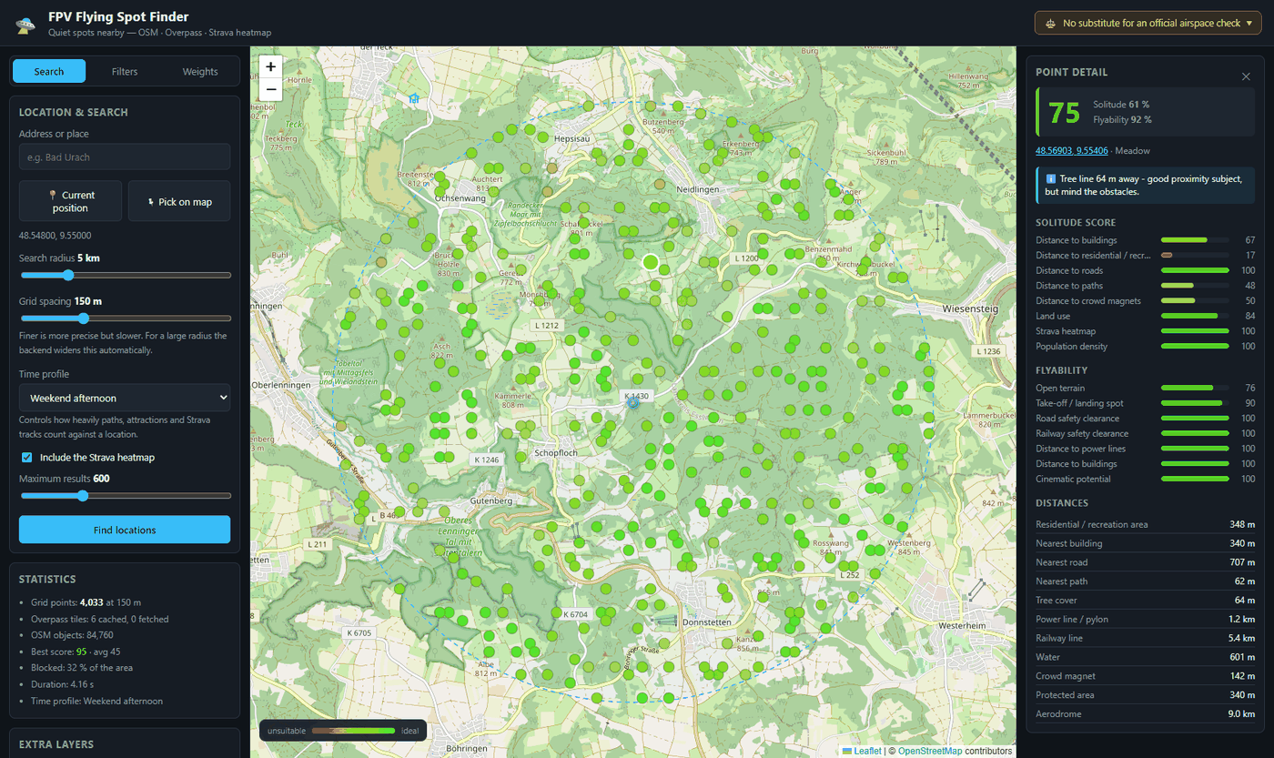
Every point inside the search radius gets two scores from 0 to 100, which are then combined by weight.
- How few people to expect: distance to buildings, residential and recreational areas, roads (weighted by traffic class), paths, playgrounds, car parks and pubs - plus the land use at that spot.
- How well it flies: open terrain, suitability as a take-off and landing spot, safety clearance from roads and railway lines, distance to power lines, and a bonus for nearby structure such as a tree line.
- Real usage, not just map data: the Strava heatmap shows which paths are actually walked and ridden. A farm track can look unremarkable on the map and still be the local after-work loop for every road cyclist around.
How the search works
Pick a starting point and radius
Type an address, use your current position, or click straight on the map. The radius is yours to choose.
Set the time profile
A farm track on a Tuesday morning is a completely different thing from a Sunday afternoon. The profile weights the leisure-driven factors accordingly.
Read the map
Green means suitable, red means not. Clicking a point shows every individual score, the distances behind it and any warnings - nature reserves or power lines, for example.
What data it uses
Openly available sources only. There is no sign-up, no user account and no advertising.
- OpenStreetMap via the Overpass API: land use, buildings, roads, paths, protected areas, power lines.
- Strava heatmap: aggregated, anonymised movement data as an indicator of which routes are genuinely used.
- Your own no-fly zones: areas you maintain yourself, such as control zones or wildlife refuges.
Frequently asked questions
Important legal notice
This tool is a research aid built on open data and does not replace an official airspace check. The EU drone regulation (2019/947), your national rules, current NOTAMs and geographical UAS zones all have to be verified by you before every flight - in Germany for instance via dipul.de or the DFS UAS map. OpenStreetMap data on protected areas may be incomplete or out of date.